
Before traveling to a new destination it is advisable to look at a map of the area, both physical and political. In this way, we can locate it, see which are the neighboring countries and where its main attractions are located. In this article, you will find different maps and plans of Italy, as well as some of its cities.
Below you have an index with all the points that we are going to deal with in this article.
Article Index
- 1.
- 2.
- 3.
Political map
Italy is a country divided into five large areas and, in turn, in twenty regions. Each of these regions has its own capital, which usually coincides with the most important city on the land.
In this table you have in Spanish each of these regions arranged in alphabetical order:
| Region | Capital | Area |
| Abruzzo | L'Aquila | Central |
| Apulia | Bari | Southern |
| Basilicata | Potenza | Southern |
| Calabria | Catanzaro | Southern |
| Campania | Nápoles | Southern |
| Sardinia | Cagliari | Insular |
| Emilia-Romagna | Bologna | Northeast |
| Friuli-Venezia Giulia | Trieste | Northeast |
| straight | Roma | Central |
| Liguria | Genoa | Northwestern |
| Lombardy | Milan | Northwestern |
| Brands | Ancona | Central |
| Molise | Campobasso | Central |
| Piedmont | Turin | Northwestern |
| Sicilia | Palermo | Insular |
| Toscana | Florence | Central |
| Trentino-Alti Adige | Trento | Northeast |
| Umbria | Perugia | Central |
| Aosta Valley | Aosta | Northwestern |
| Veneto | Venice | Northeast |
In this political map you can find the name and location of each of these regions, as well as their capital:

However, if what you are looking for is a silent political map in which only the territorial division appears but not the name of each region, this image may help you:

La amalfi coast It is a tourist area that stands out for the beauty of its beaches and its towns, which are declared a World Heritage Site by UNESCO. It is located in the southwest of the country, in the Campania region. In this map you can see the main roads of the territory:

Physical map
Italy has a total area of 301.340 km². The most prominent mountain range is the Alps, in the north of the country. Here is the highest point: the Montblanc, which is 4.810 meters above sea level (meters above sea level).
Another relevant mountain system is the Apennines, located to the south. Next to it is Sicily, an island that is considered an extension of this chain.
Italy is mostly surrounded by the Mediterranean Sea. Therefore, it has 7.600 km of coastline. The shape of the southeast area, which resembles a boot, is popular.

Tourist maps
This country is one of the most touristic in the world due in large part to the important heritage found in its cities and the millenary history behind them. These are the towns with the largest number of inhabitants.
| City | Number of inhabitants |
| 1. Roma | 2.620.000 |
| 2. Milán | 1.240.000 |
| 3. Naples | 962.000 |
| 4. Turin | 872.000 |
| 5. Palermo | 658.000 |
| 6. Genoa | 586.000 |
| 7. Bologna | 370.000 |
| 8. Florence | 358.000 |
| 9. Baric | 316.000 |
| 10. Catania | 293.000 |
Although it is not among the most populated, Venice yes it is one of the most visited cities. In this image you can see a tourist map of it:

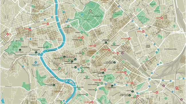
Likewise, the capital, Rome, which receives more than 7 million tourists a year, also has an outstanding number of visitors. In this map you can see the structure of the city:
On the other hand, although nowadays they are not useful, tourists and those interested in history like old maps of the countries. In this case, this map of Italy belongs to the XNUMXth century:

As we can see, it is an inaccurate map, since the technology that exists today was not possessed. Obviously, this image was designed before the unification of the country, since it was produced in the XNUMXth century.
This article has been shared 50 times. We have spent many hours collecting this information. If you liked it, share it, please:

